Tuesday, September 3, 2013

Why we carry 400' of anchor rode. . . .

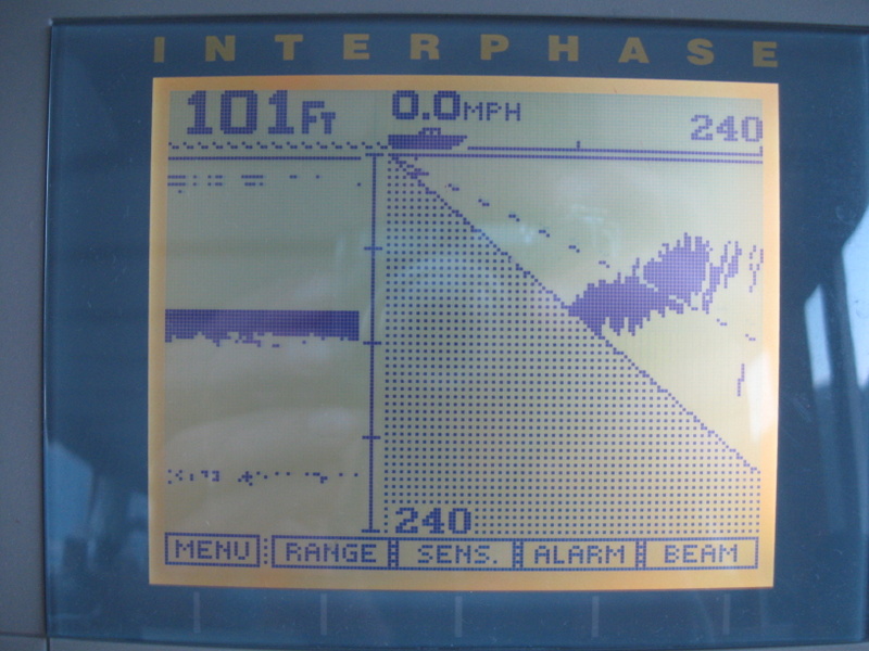
. .  in a picture:


We are in one of the few, very few, anchorable places between Jervis Inlet and Sechelt Rapids.  A 100' deep flat spot - and as you can see on the right hand side, this flat spot quickly raises to shore.

Around here, depths go from 5' to 500' in a heartbeat.  It is common to dangle your anchor onto the side of an underwater cliff and then take a 'stern line' to shore.   But this last night we found one of the few spots where we could just 'drop the hook'.   Hook, and 385' of chain that is.


Monday, September 2, 2013

Jervis Inlet and Princess Louisa

This will be the first of several posts -- I am sure -- to fit in all the wonder we saw and experienced at Princess Louisa Inlet over the past 5 days.  I'll follow my standard format when I have LOTS of photos to show:  photos with captions to tell the story.


We started out on Wed. August 28 from Green Bay, a small finger off Agamemnon Channel on the lower left (just to the right of the 'D' in 'Nelson Island'), 35 miles up Jervis Inlet, ending at Chatterbox Falls on the upper right.
                                                 

Everything is big on Jervis Inlet -- tall steep mountains, deep water, and waves and tide slow us more than we anticipated.  Al 'whips the squirrels' to make sure we arrive at Malibu Rapids at a decent time to run through.

The Young Life camp at Malibu Rapids.  Wow.  WE want to come to camp here!!!

The 'rapids' are quite calm, thank you.  We are the last boat through for the evening.

Our first look into Princess Louisa Inlet -- it is still 4 miles to the falls.

JUST before we can see the dock and falls ....

Back the way we've come.


The view from the bow of the boat for our first evening.  'Daisy' was manning the radio and informed us of available space.  Al loves sailboats -- they are easier to see through than big powerboats!

From the head of the dock, Viking Star is the last boat on the left.


The Tolly bench and its view -- excellent!

Self explanatory

Early settler of the inlet, James MacDonald, donated his claim to Northwest boaters.  


Jointly administered by Americans and Canadians, the Princess Louisa International Foundation preserves and protects this premier boating destination.  www.princesslouisa.bc.ca

The next morning we woke to a nearly empty dock!  

Fog highlights trees clinging to the nearly vertical rise of granite.

Back towards the entrance to the inlet.  The rise on the right is where the trees in the previous photo are.

The boat that was anchored in front of the falls has also left, so we move in.  What a privilege to have a front row seat!  We spend the day with our doors cracked open to hear the rumble of the water, as the rain falls, and more and MORE falls grow from threads to ribbons, necklaced by wispy clouds.

Cost to Cruise - August 2013

Kristi and I are back from almost a week hanging out in Princess Louisa Inlet, and with that comes access to Internet again, so expect a TON of post to be coming out..  An easy one is Costs, so here it is:


Viking Star Costs summary as of August 2013

Highlights include:  Paying for garbage disposal noted in Misc, and BTW:  VERY happy these resources are available for us to us - when they are..  I feel soo much better paying a reasonable fee, then being one of those 'sneak ashore' folks. . . .

Since entering Canada, Kristi and I have noticed a ping-pong on Groceries each other month being $500 vs. $1,000.  August continues that and we THINK it is associated with major restocking of meats and liquor.

Solar was off a bit, perhaps accounting for the higher generator hours vs. last August?  (That and that we are also using the Water-maker this summer).  Modeled predicted 142Ah/day in August, and we only got 125Ah this year (vs. 157Ah/day in August of 2012).  This is the largest under performance to date vs. the modeled expectation.

Not much more to say,  we just dropped anchor in 100' of water - 1st time this deep and we used all our 400' of rode.  But we are waiting for the tide to be right at Sechelt Rapids tomorrow - look them up, these are not ones to play with.

Note: Table updated Sept 4, 2013 - adding in credit card charges in Communications, and credit in Personal!

Sunday, August 25, 2013

The Calm before the Storm – literally

We have been in Pender Harbor for a few days now and it is time to move on.  Largely due to a strong low making its way into Northern Canada that will drag its cold front over our area late Monday with rain and “25-30kt” winds. Time to find a hiding place.  We will be motoring out in calm / flat waters today to Green Bay (not THAT one, the small one on Nelson Island BC).  But be quiet about this, OK?  As I don't want EVERYONE to get the same idea, there is room only for about 2-3 boats in that well protected notch.


After the front passes we will start exploring more of Jervis and Sechelt Inlets, then start working our way back South (likely to Friday Harbor) for the winter.


Saturday, August 24, 2013

Sad Happenings

It started as a beautiful morning!  The sun was shining, and there appeared to be a sailboat race setting up.  Boats were milling about, and Viking Star was right in the middle of all the action.

One went by and I noticed its pretty sails.  They were kind of translucent and shimmery.  Then the boat turned around, and headed straight for us!  I was standing at the sink doing the dishes and they were headed straight for ME!  Even though I knew they couldn't hear me I said aloud 'Pick a side.  You can't go THROUGH us.  Pick a side.'

They did, and in plenty of time.  It was a white-haired man at the helm, and a few younger people as crew.  The blond pretty woman looked up, smiled, and waved.  I raised a sudsy hand and waved and smiled back.

Then the horn blew and the race was off!

Not long later, we heard sirens.  I looked towards the public dock and noticed a fire truck at the head of the ramp.  I saw a sailboat at the end of the dock, in the space reserved for seaplanes.  Oh no.  It's the particular sailboat we had noticed.  And there was a crew of people in yellow pants with red suspenders -- were they firemen, or just sailors?  I couldn't tell.

We wanted to make a garbage run and pick up a few last fresh groceries.  It looked like the scene had calmed down  -- an ambulance left, with no lights on -- so we made our way to shore.  We noticed police on the dock as well, and determined that the yellow pants were indeed firefighters.

We struck up a conversation with a man at the top of the dock and learned that the helmsman of that sailboat -- he joins the races most every Saturday -- had apparently had a heart attack and had perhaps not even survived the trip to the dock for help.  It was the pretty young woman I saw and waved to who had run up the dock for help.

For a sailor, you probably couldn't ask for a better way to go -- quickly, on a beautiful morning, doing what you love.

But I think of that poor crew and what THEY went through.  This afternoon Al and I took a dinghy tour of some of the harbor, and passed this same sailboat again, now moored at a private dock.  Several people were sitting in the cockpit, heads together.  I hope they know people are praying for them -- even strangers like us.
Away to Pender!

On our last day at Jedediah, we were all alone in our anchorage.  Al had some projects to work on, and I put on a bikini and soaked up some rays.  Then -- what's this? -- two sail boats approach to do a rafted stern tie.  We watch for a while, of course.  And when it appears the man ashore / in the dinghy is having some trouble with his line tangling around the branch, Al offers to go to shore and assist.

THAT'S when the woman on the boat becomes more visible and vocal.  Hey.  She looks and sounds familiar.  I want to shout across 'Were you a pirate on Sucia last year?' but I figure I should wait until they are secure.  Then SHE says of Al, 'You look familiar!'  Yes, they HAD been pirates on Sucia, and I had given her the prize for best woman's costume.  Later, another couple came over from their boat in Deep Bay, and she said 'You gave ME a prize too!'  Her husband had won the best man's prize, and she had been his parrot.

We met the first couple last fall on Blake Island too.  VERY small world!

Thursday we crossed over to the mainland and Pender Harbour.

This view had me singing 'I Can See For Miles'.  And miles and miles and miles and miles!  When looking this direction, the Strait is open for 60-80 miles before landfall.  Al tells me that, based on height of eye and curvature of the earth, the ACTUAL number of miles I can see is only four.

Past the tip of Texada Island and toward Pender Harbour.  I don't know what that peak is really called, yet, but for now I will call it 'Sharp Tooth'.

Yesterday, we 'went to town' for coffee at Java Docks (it was okay) and to grocery shop.  We also walked up the hill to Rona, the hardware store, to buy velcro dots to mount the carving we bought from Gil on Penelakut.

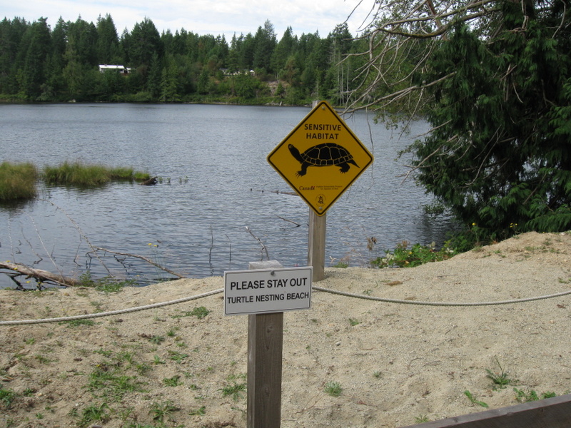
On the way, we saw an interesting sign:


And a few more:


We didn't see any turtles though.


Friday, August 23, 2013

Jedediah Hike

This hike took place three days ago -- we are already across the Strait at Pender Harbour.  I am behind partly due to having no internet while at Jedediah.  Here we go.  LOTS of photos, so I'll just caption with short commentary.

Our first Jedediah sunset.  I love how the sun gilds the edges of the clouds sometimes.  An added highlight -- someone across the passage at Boho Bay is playing bagpipes!

Next morning, low tide.  We are surprised to see a huge rock in the bay (not on the charts).  Al takes a tour around Viking Star to see if one might be popping out below US!

A Parade!  Three identical boats, even to the dinghy.  Al called them PDQ Cats.

A lovely lavender lady

It's low tide, and we plan to be away for hours.  We need to haul the boat further up shore for the line to reach to something to secure it too.  Yes, the dinghy was floating when we returned. 

Someone built a 'shelter' complete with benches.  Al is standing in the firepit.

Deep Cove from another perspective.  The 'cats' are arriving, No. 2 is on the upper left.


This guy reminds me of the talking trees in The Wizard of Oz.

This map confused us for a moment, until we realized North was to the BOTTOM.  Odd, but it matched OUR orientation as we faced the sign.

A 'snake' log

Into the meadow

Most of the trees in the orchard -- pear, apple, walnut -- had sparse fruit.  The pears were most prolific.

Home Bay dries at low tide.  This is the view from the house.  There are several tents across the bay, and a couple of boats anchored behind the rock outcropping on the right.

Sad to see the house and other buildings decaying.

We cannot escape airplane noise.

Home again.  You can see that big rock has been covered with water now, and there is about 8 feet to go before high tide.