Thursday, June 30, 2016

Kingcome Inlet


From Sullivan Bay we went to Greenway Sound which was wonderfully reflected in glassy smooth water. We found where the marina USED to be. It was a wonderful spot, but too deep to anchor. We took a short tour and found that the southern section had extensive logging visible, so we returned to the mouth of the inlet.

A sailboat, whose crew we had met at Sullivan Bay, occupied our first choice of spots, so we nosed around an islet -- a quite nerve-wracking experience for me where I was to be on bow watch, and it was NEEDED -- and anchored in 65-80 feet of water, depending on the state of the tide.  We knew it was a rock bottom because we could hear the chain rubbing as we shifted. It sounded like rumbles of distant thunder. We both said we were glad our cabin is in the rear of the boat where we couldn't hear it as well.


Not everything we see is beautiful. Everywhere we go there is evidence of logging. This is along Sutlej Channel. Mostly it doesn't bother us, unless it is CLOSE like this is, or a recent clear cut.


Kingcome Inlet reminded us much of Knight Inlet, though shorter and narrower. It was a sunny day, and glorious. It got me to thinking -- this was only the third DAY of sunshine in six weeks in the Broughtons! A day going up Knight Inlet, a day in Booker Lagoon, and now a day in Kingcome Inlet. We may have had sun breaks, a few hours of sun here and there, but not days. 

Try to imagine the two pictures below as one big panorama. (Google editor won't allow me to align them together...)


This is our entrance to Kingcome Inlet.


In the area where Wakeman Sound branches off from the Inlet, we saw dolphins in the distance. Then a whole pod were racing across the inlet, passing right in front of us! It looked like it truly was a race, as they barreled right up to a rock on shore!

The race begins

The finish line!
Even though we have discovered how to set the camera to continue shooting as you hold down the shutter button, dolphins move SO quickly that they are very difficult to capture. I told Al as I was shooting that I would have over 200 pictures to go through. But at the end of the day, it was 426. On the first edit, over 200 were deleted.


Bronson wanted to see what all the commotion was!

Just above Wakeman Sound, this mountain has TWO very interesting features.

A lacy, humpy waterfall

And very little water, but a big SWOOP at the end would make quite the waterslide!

Charles Creek. The jetty in ruins once served a cannery, perhaps around 100 years ago...

The end seems SO close, but it is still 6 miles away!

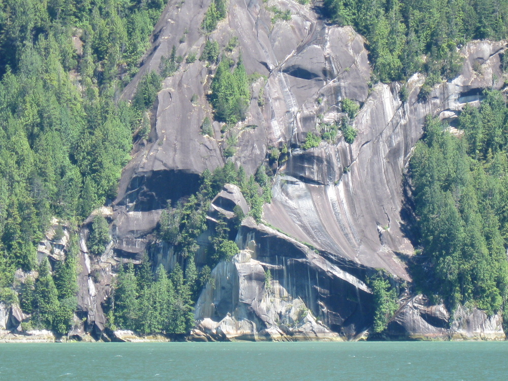
Around the corner to the left, we are looking for a 'modern pictograph'.


This is NOT what we had in mind!

To be honest, when I first saw a picture in a guide book, I was all ready to not like it. It just didn't seem to 'fit', in my mind, of something to put on a natural feature. BUT, now that I've seen it 'in real life', I love it! It measures 26 feet x 38 feet, but everything here is SO big, that this is almost dwarfed.


My picture looks nearly identical to the one published in Waggoners.

Turned around and heading back, we see 'the pokey mountain' in the distance. It appears he is playing Joe the Volcano.

As we returned down the inlet to Belleisle Sound, the dolphins were ready for more interactive play! They followed us for quite a stretch, playing in our wake, swimming alongside, and diving under the bow. Magical!


WOW! Right along side!

We liked our anchorage so well, we stayed two nights!

Port side, looking north.

Across the bow, looking east.

A Belleisle sunset!

Saturday, June 25, 2016

Sullivan Bay Marina

We splurged and spent a night in one of the few 'must stop' marinas in the Broughtons. We were met at the dock by the manager, and at the store we met the other manager. We got the last cinnamon roll for the day, and skipped lunch to save room for the prime rib dinner the marina staff prepared and served that night. It was SO yummy!


Main Street. 

Lots of flowers everywhere, especially on the decks of the resident float homes.

I think we went over the speed limit! If you walk all the docks, from the 'airport' and down each of the 4 fingers, they say it is 1.3 miles. I'm sure it didn't take us an hour.

We also traded read books  for unread ones, and chose some magazines from the stacks (most in the 2009-2011 vintage).

Thursday, June 23, 2016

Finding Nimmo

We don't 'watch TV' while cruising. We 'watch shows'. This summer, one of the shows we are watching is Boston Legal. And at the end of Season 1, Denny Crane talked of a resort in British Columbia in Little Nimmo Bay. In Season 2, Episode 3, Denny and Alan Shore actually go to the resort. Hey, we should go check it out!

We'll call this part of our cruise, departing from Booker Lagoon 5 days ago, 'Finding Nimmo'.


We head up Wells Passage and this many-peaked mountain is peeking through the clouds.
We learned later that it is Mt. Stephens, but it remains 'the pokey mountain' to us.
Five days later, this is the best shot I will have of it.

We spent two evenings in Claydon Bay, where we found Red-throated Loons. The Sibley Field Guide to Birds of Western North America says that their voice is 'quacking or gull-like wailing'. We learned that yes, they do quack. But the wailing seemed much more like SHRIEKING! Al even thought they were coyotes or wolves howling. Across the water and echoing off the mountains it was quite unnerving. And this is also the best picture I have of them.

Roaringhole Rapids IS roaring. This short passage has only 3 feet of water in it at low tide. NO, we are not going to attempt it. Another reason? Slack only last for 5 minutes and there is no anchorage above in Nepah Lagoon to wait for the next slack.

In Turnbull Cove we were one of 10 boats, the biggest number we have seen gathered in one spot,
except for marinas, since heading north. This is facing AWAY from the boats. The bright green area on the left marks an old landslide. The bigger, newer (2005) one is on the north shore. And oh, I wish I'd told the sun to come back soon!

Next day, we head down dramatic Kenneth Passage. The current creates whirlpools and boils in the water, and the foggy/rainy mountains remind us of the Columbia River Gorge.

We enter Mackenzie Sound and turn right, and I look back at the sheer granite wall of Annie Point, and see 'the pokey mountain' through the rain.

Burly Bay has its own granite wall. We are hopeful for bear on the beach, but we don't see any, and we haven't even seen many birds. And we had thought the forecast had only talked of one night of rain. Nope.
 After a night in Burly Bay, and hearing that strong winds are forecast in a few days, we want to find Nimmo and travel to the end of Mackenzie Sound and find a sheltering anchorage to wait the winds. So, when the rain stops for a bit and the clouds seem to be lightening, we pull anchor and head out.


The guest cottages

Kitchen/dining room/communal area?

There are even tail-wagging greeters! There was a third, but he lost interest before these two.

Appears to be staff accommodations.

DO check out their webpage. This is a VERY luxury resort, but they will welcome boats, with reservations. Being quite frugal, we didn't plan to stay.  But wow! You can arrive/depart by helicopter!  We think THAT trip may be worth the price....http://nimmobay.com/packages/welcome-boaters/


This is a pretty picture of the head of Mackenzie Sound. But to be honest, we were quite disappointed. Because just to the right of this is a dock and landing for a logging operation. There were several vehicles, fuel tanks, storage containers, and a big boat, with people on it. Anywhere we would have anchored would have been in sight. Blah. So we headed back to Burly Bay.

Next big destination is Sullivan Bay where we will be getting a few groceries and practicing our people skills again.  How soon we get there depends on the weather.

Saturday, June 18, 2016

Booker Lagoon

Booker Lagoon is a large lagoon with a very narrow, but deep enough, entrance. Because it is narrow and large amounts of water need to get through with the tides, current can be very speedy. We had planned to anchor in Cullen Harbor, just outside Booker Lagoon, since we were arriving an hour after what the guidebooks would say the best time to transit would be, but we stuck our nose into the entrance and it didn't seem too bad so we went for it! No problems.

We poked around a bit, and every nook we thought would be interesting already had a boat in it, so we moved east. Winds were predicted to be light, but from a direction that would rock us if they picked up. Hey, this time the forecast held up, and we bounced only a little bit.

We liked our vantage point of the water in that we could see boat traffic coming and going. And we kept an eye on the sailboat anchored in the spot we were coveting. Except that it ducked in and out of view depending on the tide and winds.... and we didn't see it leave. That's okay, it was a rainy wet day and we didn't feel much like going out and pulling the anchor to move.

Next morning dawned with beautiful sunshine! And since we hadn't been able to spot that sailboat since the day before, we decided to move. And wow, it IS a sweet spot! The sunshine turns everything into jewels.

View west. Around these islands to the left is the entrance/exit.

Our new little cove has a 'window' onto Booker Passage. Zoom in, and we can see the current RUSHING in,
 and logs twirling in the back eddies.

Zoom out, and it's harder to see.

Zoom in and you can see a crabber zoom out! What a bow wave on that opposing current!

Behind us, a little island we passed to enter appears to have a grassy area, and maybe a fruit tree? We have heard you can see bear in this area, but the shoreline doesn't seem like the areas where we have. This perhaps looks promising?

An eagle family indulges me. 

Young and old.....or....mature.

Al found the mode on the camera that can take repeated shots when you hold the shutter down. It is fun to quickly click through the ones I took of this sailboat leaving. We saw this Australian boat watching grizzlies at Glendale Cove!

Time for a dinghy trip! First stop is the little island in the first picture of this post.

Rockweed. I always think it looks like little balloon pants.

Jewels, I tell ya! Everything sparkles in the sun. This is another little window onto the channel, but too narrow and shallow for the dinghy.


Now we've moved to the little island with the grassy patch.
Turns out the grass is not like a 'lawn'-- it is a type of sea grass. Duh.
And the tree is not a fruit tree. I think it is an alder.
The 'lava rocks' make me think of the grandkids.
Hello Viking Star!

The pass between the little island and the big island's shore make me want to do a slow float with the current.
So we do!
Another view before we get in the dinghy and paddle to the entrance.


No motor. No gas fumes. So lovely.
We've been kissed by the sun today. We have a rosy glow, but no regrets. And, since there are no big mountains to block it here, and the sun is actually shining today, we get a REAL sunset.


Official sunset is at 9:48. This is a bit sooner, due to the hill.


An hour later.
Loving the lingering glow.