After my 'Lonely' post, I decided that if I wanted more time with my husband, I should just BE with him more. Two SUNNY days made it easy! We took a 3-4 mile hike, clipping weeds and branches on the way. And yesterday the ranger gave us a couple of projects that involved driving a park truck to the other side of the island.
 |
| That's a strange bouquet Al has picked! It's a tent caterpillar infestation, and he clips the creepy crawlies.... |
 |
| And takes them to the water's edge, fastening them with a stone, for the tide to dispatch with. |
 |
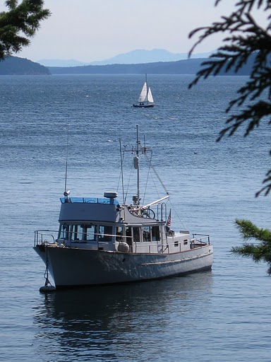
| The Oyster Hunter taking a lunch break. |
 |
| The view south from Johnson Point, Snoring Bay in the foreground, Orcas Island and Turtleback Mt across the channel. |
 |
| The view east from Johnson Point, Matia Island with Mt. Baker and the Cascades beyond. |
 |
| On the point, we found this plaque |
 |
| And this replica monument. |
Click on the pictures to read them full-size. The original monument was placed in 1892 by Reginald Thomson, United States Mineral Monument No. 1.
 |
| Another plaque showing Lat and Long, referencing the Willamette Meridian |
 |
| If you read the first plaque, this is the original U S M M carved into the sandstone next to the monument |
 |
| And this is the 'large gray snag' used as a bearing tree, to mark the spot of the monument |


The survey markers that you mentioned where the meridian passing through and referances the Willamette Meridian. Actually Meridian and Baseline meets on Skyline ridge in Portland, OR. (I could take you there when you are back in town, so you can say you have been there.) and it goes from the West Coast to Meridian, ID from East to West and it goes from California to the Canadian boarder. Lewis & Clark were the origional surveyers. Brian
ReplyDelete